Monday, April 27, 2009

Unstandardized Choropleth Map


These maps have no ranking assigned to the classes. This map shows determinants of landowner income.

http://www.cabnr.unr.edu/kilkenny/APEC460660/Land%20Rent%20and%20Value_files/image006.jpg

Thematic Maps


Thematic maps show information on a topic superimposed over a base map. This map is of population percent change in the United States.

http://www.sou.edu/Geography/JONES/GEOG280/stpop96.GIF

Univariate Choropleth Map


Univariate Choropleth maps display a single set of data. This map is of the poverty level in the United States.

http://www.cdc.gov/PCD/issues/2007/oct/images/07_0091_01.gif

Bivariate Choropleth Map


A bivariate choropleth map displays two variables on a single may by combining two different sets of graphic symbols or colors. This map is of land use and life expectancy in Africa.

http://www.geocities.com/stevejford/Africa_Choropleth.jpg

Unclassed Choropleth Map


An unclassed choropleth map does not define classes. This map is in regards to fertility rate.

http://www.esds.ac.uk/international/images/uchoropleth.gif

Cartographic Animation


Cartographic animation is a visualization that evolves through various interval changes in the display. This is a cartographic animation of Mt. St. Helen's.

http://www.3dnworld.com/users/1/images/mshcart.jpg

Digital Orthographic Quarter-Quads


DOQQ's combine the image characteristics of an aerial photograph with the geometric qualities of a map. This image is of Pine Knoll Shores/Indian Beach.

http://www.geodynamicsgroup.com/images/shoreline_chng1.jpg

Digital Elevation Models (DEM)


Digital Elevation Models are digital files consisting of terrain elevations for ground positions at regularly spaced horizontal intervals. This picture is used by a software company to show what they can produce for their clients.

http://www.tarin.ca/images/dem.gif

Digital Line Graph


A Digital line graph contains a wide variety of information such topography, boundaries, roads and utility lines. This graph is for the Iowa Department of Transportation.

http://www.iowadotmaps.com/msp/images(help)/storyimage.gif

Digital Raster Graphics (DRG)


DRG is a scanned image of a U.S. Geological Survey standard series topographic map. This is of the Colorado River area.

http://www.tceq.state.tx.us/assets/public/gis/images/drg.gif


Isopleths are lines drawn on a map through all points having the same numerical value, as of a population figure or geographic measurement. This map shows water quality data in Kings County, Washington.


http://proceedings.esri.com/library/userconf/proc95/to200/p1748.gif

Isopach


Isopachs are lines drawn on a map connecting all points of equal thickness of a particular geologic formation. This is of an oil field reservoir.

http://www.glossary.oilfield.slb.com/files/OGL98135.gif

Isohyets


Isohyets are lines drawn on a map connecting points having equal rainfall at a certain time or for a stated period. Here is one from Taranaki, New Zealand.

http://www.trc.govt.nz/environment+online/rainfall/images/aug08isohyet.jpg

Isotachs


Isotachs are lines on a weather map or chart connecting points where winds of equal speeds have been recorded. Here is an example of isotach map showing wind speeds throughout Florida.

http://weather.cod.edu/help/850tach.gif

Isobars


Isobars are lines drawn on a weather map or chart that connects points at which the barometric pressure is the same. This maps shows the pressure in Rapid City, South Dakota on May 6, 1999 when they were experiencing strong winds.

http://www.crh.noaa.gov/Image/unr/05-06-99/99050612_sfc.gif

Lorenz Curve


A Lorenz curve shows the degree of inequality that exists in the distributions of two variables, and is often used to illustrate the extent that income or wealth are distributed unequally in a particular society.

http://www.unc.edu/depts/econ/byrns_web/Art/Glossary/LorenzCurve.jpg

Stem and Leaf Plot


A stem and leaf plot displays quantitative data. This plot displays hours of sleep.

http://www.qacps.k12.md.us/cms/sci/tools/lineplot.jpg

Box Plot


A box plot is a data table.Each column of the data table forms the basis of a box plot, thus a table with, for example, 5 columns results in 5 box plots which are arranged in the same order as the columns. This is an example of a box plot that a software company displays to explain this plot.

http://www.lohninger.com/comimg/boxplot.gif

Histogram


A histogram displays tabulated frequencies. It summarizes discrete or continuous data that are measured on an interval scale. This histogram shows the salaries at a corporation.
http://www.statcan.gc.ca/edu/power-pouvoir/ch9/images/histo1.gif

Parallel Coordinate Graph


The parallel coordinate graph is multivariate and has specific properties that correspondes with two geometrical properties of the graph. This graph is an analysis of the parallel coordinate graph and shows analysis and control.

http://www.caip.rutgers.edu/~peskin/epriRpt/images/PCoords2.JPG

Triangular Plot


A triangular plot displays the data of three variables. This triangular plot displays data in regard to conduit fragmentation, cave patterns, and the localization of ground water basins in the Appalachians.

http://www.speleogenesis.info/archive/sg2/White/img/SG2_White_basins_f10.gif

Bilateral graph


A bilateral graph display data when there are both positive and negative values. This is a graph of an annual economic report. It shows demand and long term deposits.
http://www.resbank.co.za/Economics/year96/graph/graph28.jpg

PLSS


PLSS stands for Public Land Survey system and covers the entire United States. It uses a series of 34 principle meridians and baselines. It has plots that are called townships that are subdivided into 36 sections. This PLSS is from Minnesota.

http://www.fairview-industries.com/standardmodule/mn-exmp2.gif

Hyposometric


A hypsometric map displays elevation. This hypsometric map uses contour lines and is of a hydrographic basin.

http://www.esteio.com.br/imagens/se-LhipsoCurva.jpg

Cartogram


Cartograms are maps created by substituting a different standard of measurement for distance or area. This cartogram shows allotment of electoral votes.

http://www.cartisan.com/map_resources/map_types/images/cartogram_1.jpg

Topographic


A topographic map uses contour lines to portray the shape and elevation of the land. This can be seen in this map of Crater Lake in Oregon.

http://vulcan.wr.usgs.gov/Imgs/Gif/CraterLake/Maps/crater_lake_topo.gif

Planimetric


A planimetric map is a surface map with no relief features such as a street map. This map is a street map from New York.

http://www.nysgis.state.ny.us/mapssales/gifs/lakegeo.jpg

LIDAR


LIDAR is a type of remote sensing that uses laser (light amplification by stimulated emission of radiation) instead of radio or microwave radiation. This LIDAR image of Kansas City is from an unedited first return data.
http://www.imagingnotes.com/ee_assets/email_images/Lidar_KansasCity_MJHarden.jpg

Windrose


A windrose is a map symbol showing the strength and frequency of wind from various directions. This windrose is from Seattle, Washington.

http://www.climate.washington.edu/windrose/Seattle-WindRose.jpg

Classed Choropleth


Classed choropleth maps portray areal data. Data for states, counties, etc. is combined into a small number of groups and portrayed in intervals. Four to seven groups are used. This map identifies regional variations of life in Brazil.

http://curriculum.qca.org.uk/uploads/itm-2104_tcm8-4685.JPG

Infrared aerial photo


Infrared photographs are a type of remote sensing that uses false color due to the fact that we can't see the wavelengths that are recorded on the film. This is a photo of the Waccamaw Drainage System located in southeastern North Carolina.

http://www.ncwater.org/Reports_and_Publications/waccamaw/34.jpg

Doppler Radar


Doppler radar is a type of remote sensing. It is a radar that uses a transmitter to emit microwave radiation and a directional antenna or receive and measure the time of arrival of reflected pulses of this radiation from distant objects. This Doppler radar is profiling Hurricane Charley in 2004.

http://www.weatherusa.net/blog/images/doppler-orlando-1943.gif

Black and white aerial photo


Black and white aerial photos are a type of remote sensing. They are coated with a black and white emulsion that is sensitive to approximately the same wavelengths as the human eye. This aerial photo is of White Lake in Wisconsin.

http://www.whitelakepoa.org/2006%20White%20Lake.jpg

Climograph


A climograph shows monthly precipitation and temperature conditions. This climograph is from Iqaiuit, NU, Canada.

http://geography.ridley.on.ca/CGC1D/Students/Canada%27s%20North%20Web%20Page/Climographs_files/image003.png

Population Profile


Population profiles show demographic statistics. This population profile shows a projected population structure with and without the AIDS epidemic in the year 2020 in Botwswana.


http://www.ifad.org/operations/regional/pf/figure1.gif

Sunday, April 26, 2009

Index Value Plot


An index value plot is a line graph that is a type of visualization map. This graph plots the market risk of a hypothetical global equity index portofolio.

http://www.mathworks.com/products/demos/shipping/garch/garchcopulaevtdemo_01_thumbnail.png

Scatterplot


Scatterplots are drawn in two dimensions and shows correlations between factors such as such as their interactions. This particular scatterplot shows the correlation between age and maximal heart rate under stress in regard to heart disease.

http://www.ailab.si/janez/scatterplot.png

Star Plot


A star plot shows the relative behavior of all fariables and is multivariate. This image shows selected peak ratios from oil fields in Taluka and Numbi. It shows that the oil reservoirs may have similiar fingerprints but still have differences.


http://www.humble-inc.com/app99-2-fig4.gif

Correlation Matrix


A correlation map shows correlation between data. It has two triangles with values below and above and are symmetrical. This map shows the accuracy and precision of objective refraction.

http://www.journalofvision.org/4/4/9/figa10.gif

Similarity Matrix


A similarity matrix shows similarities such as in this map. This image uses red and orange colors to indicate similar potentials in regard to electrostatic.


http://pipsa.eml.org/pipsa/pipsa-example.png

Range Graded Proportional Circle


A range graded proportional circle map uses ranges to depict the values of each circle. This map shows that most of the EID events in the United States take place in the northeast.

http://www.nature.com/nature/journal/v451/n7181/images/nature06536-f2.2.jpg

Isoline


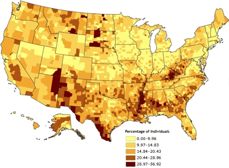
An isoline map is a map with continuous lines joining points of the same value. Examples would be equal altitude (contour lines), temperature (isotherms), barometric pressure (isobars), wind speed (isotachs), wind direction (isogon), wind shear (isoshear), etc. Isoline mapping is used to interpret the information on some thematic maps. This particular map shows natural conditions in the proposed water transfer region in China.

http://www.unu.edu/unupress/unupbooks/80157e/80157E0T.GIF

Continuously Variable Proportional Circle


This is a map which utilizes circles to create point data that relates scales to specific data. Circles are in proportion to variable being measured. This particular map illustrates with propotional circles the American Indian population of each state.


http://www.neiu.edu/~nerobert/Circle%20Map.jpg

Statistical


A statistical map displays the distribution of a certain variable over a geographi area. It can sometimes be displayed by rates, ratios, and percentages. This graph displays Napoleon's Russian Campaign of 1812. The lower portion of the map shows retreat information correlated with temperature.

http://media-2.web.britannica.com/eb-media/87/75087-004-15555631.gif

Dot Distribution


Dot distribution maps are useful in showing population. This map shows the population of the the Emperor Dragonfly. It is broken into categories of proven (large dot), probable (medium dot), and possible breeding (small dot).

http://www.brocross.com/dfly/species/maps/anax.gif

Propaganda


This image is propaganda as it is trying to persuade people to think one way or another. The Chinese government has blocked YouTube access for all of China, including Tibet. Students show their protest by this image of the Network Security Police.
http://www.globalvoicesonline.org/wp-content/uploads/2007/08/jingjing.gif

Flow


A flow map shows the actual path of entities across a surface and the intensity of travel along these paths. This map is a very simple type of flow map. It shows a student's movements in preparing for a day at Frankley Elementary School. Instead of merely listing the schedule the student has shown the flow beginning with getting up at 7:15 a.m. and ending with arriving at school.

http://www.frankley.school.nz/uploads/images/flowmap_lge.jpg

Cadastral


This is a cadastral map from Australia. A cadastral map shows boundaries and property lines. As you can see in this map there is not a lot of detail; it merely let you know where the boundaries are located.

http://www.sli.unimelb.edu.au/subjects/451/418/418_2001/images/lecture08_8.jpg